Saturday, May 29, 2010

Sleeping With Compression Shorts

CHAPTER 17 .- ANGOSTURA BRIDGE (PART 2).


" Theory is when you know everything and nothing works ;

practice, when everything works and nobody knows why. "

-Anonymous


ANGOSTURA BRIDGE (PART 2)

Hello and Welcome, as always SOMETHING NEW IN TOURISM.


remember that last week brief talk on the history of our Angostura Bridge, essential data, cost and a preamble to the location.


As mentioned above, were taken at three sites where you take out the bridge construction, these sites are: STONE MIDDLE ISLAND OF THE DEGREDO and between PUNTA and CHACON PLAYA BLANCA . Now, why we chose the latter and not the previous two?

The idea of \u200b\u200bbuilding it in MIDDLE STONE was rejected for reasons urban. If built there, would have relocated much of the population of Ciudad Bolivar and the problem of motor traffic would have been catastrophic.


For the type of bridge that was it, would be built on the outskirts of the city, as this is purely highway bridge. In addition, the historical aesthetics of the city had been disfigured beyond repair.

build in THE ISLAND OF THE DEGREDO , its cost would have been much higher, as would have been double its total length, in addition to ruin an island that has its place in history and had Angostura created Additionally, traffic problems and the relocation of the population of the city. Therefore, the most viable option was the third, the site is between PUNTA CHACÓN in Bolivar and Playa Blanca in Anzoátegui state.
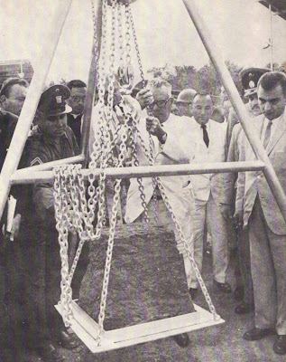


Foundation Stone laid by Venezuela's President Rómulo

Betancourt. (Photo: Angostura Bridge over the Orinoco River . Caracas, 1967)


The reasons why they decided to build on this site, the report Technical reflected in the book ( ANGOSTURA BRIDGE ON THE RIVER ORINOCO, Ministry of Public Works. Caracas, 1967 ) are:


"a) Although the length of the bridge is nearly equal to Site Middle Stone, no relocation of population problems and expropriation.


b) The cost of the bridge on this site is about half of what would have cost in the Degredo, due to their shorter length.


c) In the current site there are no problems of expropriation, which would not have happened in the other.


d) As the river bed is rocky on this site is ideal for melting.


e) The construction of the bridge in Punta Chacón allow the development the city westward, pursuing a new area "


We have said that the Angostura Bridge road and is clearly mixed type because it is part of a road system important because the main part of this structure is part pendant and access sections of prestressed concrete. The total width of the bridge is 16.60 meters, divided into four trails 3.65 meters, and two sidewalks of 1.0 meters each.


BRIEF GEOLOGICAL SURVEY FOR FOUNDATIONS.

During the years 1963 and 1964, after the official start of construction work, we proceeded to study the basement where the batteries would be placed. The CANADIAN FIRM HUNTING SURVEY CORPORATION LTD., Conducted a preliminary study based on Hidrosonda, which showed as a result, the existence of a deep pit in steep walls that begins in Punta Chacón. Because it was decided to place the stack N º 8 in what we call Chacon peninsula (see Figure Geological Survey for the Foundations) to avoid deeper base due to the inclination that we mentioned.

Geological Survey Scheme for Foundations.

(Graphic: Angostura Bridge over the Orinoco River. Caracas, 1967)


The main material of all the foundations of the South (Bolívar) is the granite rock, in the foundations of the north side (Anzoátegui) predominates Sienite DARK GRAY. (see concepts below)


Granite: deep rock best known and most widespread. Consists mainly of quartz, feldspar and mica and hornblende, augite, tourmaline, zircon, magnetite, etc.. Components, arranged without any direction and usually of equal size, are crystalline and fine to coarse grain. As the major components are distinguished Granite biotite Granite Granite Micaceous and amphibole. There are red granite, blue, gray, etc. (Dictionaries Rioduero, GEOLOGY AND MINERALOGY, 1985).


Sienite: Deep Rock similar to granite; is grayish-white or reddish gray, plutonic, low in quartz and feldspar composed of red and amphibole, biotite or pyroxene . Is less widespread than granite. (Dictionaries Rioduero, GEOLOGY AND MINERALOGY, 1985).


Other materials underneath (underground) of the structure the bridge are: Soft Clay loam, sandy clay Tiesas Mostly, hard black biotite schists, massive rocks, including granite and syenites Gris Pink Dark Grey, loose sand Fine to coarse filling the riverbed, Peñones Layer Fill in bed Rio (See definitions in technical and scientific concepts, higher or visit elblogdelgeologo.blogspot.com )


There are many technical issues to talk about our neglected and marginalized bridge, but will touch here only the highlights of the topic as TOWER BRIDGE are structural steel section and the type of cell. Each is 119.175 meters in height, measured from its base and 140.585 meters height measured from the zero level of river.


is a tribute to give due recognition to the designer and driver of this impressive piece of engineering of our Guyana: illustrious son of this land, once ANGOSTURA, ENGINEER PAUL LUSTGARTEN.

is quite unfortunate that many of those who live here do not know who the strongholds that hold the culture, history and progress of our region, our city.


Timing of last section to finish up construction of the tower. (Photo: Angostura Bridge over the Orinoco River . Caracas, 1967 )


SOMETHING NEW TOURISM intrinsic aims to bring every one of you, valued readers, tools reflected in historical documentation, scientific, tourist and lore to heighten our gentile, recover lost values \u200b\u200band let the world know that Ciudad Bolivar, Venezuela has a voice and has much to tell.


Detail of one of the access section of the bridge during

construction. (Photo: Angostura Bridge On the Orinoco River . Caracas, 1967 )

New Lcd Tv Looks Blurry In Non-hd

CHAPTER 16 .- ANGOSTURA BRIDGE (PART 1). CHAPTER 15 .- LA


" A not artists must be made to monuments

because the have made their works "

- Antonio Gaudi y Cornet

ANGOSTURA BRIDGE (PART 1)

Hello and Welcome, as always SOMETHING NEW IN TOURISM.

remember that last week we completed the subject of the Orinoco, playing interesting topics as the possibility that our Rio Father, theoretically speaking, could ever lead to millions of years ago by a delta located near what is now called Urumaco in Falcon state, due to the existence of fossils typical of large rivers and evidence of a deltaic environment of transition, which suggests the aforementioned theory. But this is only theory, nothing is confirmed.

speak of some fossil remains outstanding as Purussaurus (Cayman Gigante) STUPENDEMYS Geographicus, (also called Uruma Giant Tortoise) and Phoberomys pattersoni (like Giant Rodent the capybara).

Our river is full of history, myths and legends has witnessed Republican evolution and progress of the country continued to experience this vibrant land.

For this reason, we will discuss the first bridge that joined our geological mole called Guyana, with the rest of the young northern Venezuela what we now call that only about 25 million years, about 3 000 575 000 000 years younger than our mountain.

Angostura bridge location, between Punta and Playa Blanca Chacon.

(photo: Alexander Lamb)

ANGOSTURA BRIDGE.

First, it is fair to say that the main source of information we will share is from the book ANGOSTURA BRIDGE ON THE RIVER ORINOCO, 1967. This book was reissued by the Corporacion Venezolana de Guayana in the year 1989 due to the importance of teaching and professional reference it represents, but its original publication was made by MINISTRY OF PUBLIC WORKS-HIGHWAY MANAGEMENT during the presidential term of Dr. Raúl Leoni, along with Leopoldo Sucre Figarella, Minister of the portfolio in question.

ANGOSTURA The BRIDGE on the magnificent Orinoco River was begun by placing the first stone 19 December 1962 by President Romulo Betancourt of the time, with the aim of uniting the two banks of the river, north to south.

was inaugurated on 6 January 1967 , Dr. Raul Leoni, who was president of the republic at that time, giving the service the public. For the opening date, this bridge was the largest suspension bridge in South America, the fourth of the world outside the United States and the ninth in the world including the United States. Today is THIRTY SEVEN LONGEST BRIDGE IN THE WORLD. was designed by the Venezuelan architect Paul Lustgarten, talk about it later.

SOME TECHNICAL DATA.

is located 5 km upstream of Ciudad Bolivar and communicates our states Anzoátegui and Bolivar. Angostura Bridge has 1678.5 meters in length, distributed as follows: LENGTH OF ACCESS NORTH: 151.75 mts.; LENGTH OF SOUTH ACCESS: 254.75 mts.; LENGTH OF SECTION NORTH SIDE PENDANT: 280.00 mts.; LENGTH OF SECTION SOUTH SIDE HANGING : 280.00 mts.; LENGTH OF MAIN SPAN: 712.00 mts.

Other interesting facts as HEIGHT OF THE TOWER ON THE PILLARS: 119.2 mts. ; HEIGHT OF THE RIVER LEVEL TO THE BASE OF THE STRUCTURE OF PENDANT: 40.00 mts , and has 2 WIRE WITH DIAMETER OF 47 cms. EACH , Containing 7,182 WIRE CABLE, for a TOTAL LENGTH OF 19,800 miles of wire. were used 20,034 TONS OF STEEL and 97,828 meters. CONCRETE CU.

BRIDGE ECONOMIC SURVEY ANGOSTURA .

Total Investment Cost of Bridge and Access Roads amounted to Bs 177,512,000, plus the cost of maintaining Bs 663,000, a total of 178,175,000 Bs We're talking, of course Bs in the sixties. A trifle compared with the current value.

three important aspects were considered: a) CONSTRUCTION COSTS of the Work, as we mentioned, amounts to 177,512,000 Bs and distributed construction of bridges and roads access, b) COST OF MAINTENANCE and management of structures and units that were estimated at 663,000 Bs and finally, c) DIRECT BENEFITS of road users in the form of reduced time and costs operation, were determined by comparative cost analysis of services provided by the bridge and the ferry. Visit our blog to see the tables with technical, economic and statistical bridge.

jumper location.

For the construction of the bridge led to three possible places that were built for study, these were:

a) Site BUILT ENVIRONMENT.

b) Site DEGREDO ISLAND and

c) site between CHACÓN and PUNTA PLAYA BLANCA 5 kilometers upstream of the city.


Degredo Island Site. Second option was to consider building the

bridge. (photo: Alexander Lamb)


Our Majestic Puente Angostura. First Wonder of Engineering About our Orin oco


Can You Drink Perrier When Pregnant

ORINOQUIA (PART 2) THE GIANTS OF THE ORINOCO. CHAPTER 14 .- LA


"Nature herself enough; so with less and ends with safe, the excesses of hope "

- Democritus .

ORINOQUIA THE (PART 2)

ORINOCO GIANTS

Hi

Welcome everyone and, as always, SOMETHING NEW IN TOURISM . We were away for a time by academic and work commitments but WE ARE BACK ON LINE . The last time we talked about the Orinoco region, stressing that this refers to the unique geographical region of Colombia and Venezuela and is defined by the basin Orinoco river and characterized by crossing the Plains region, which possesses a rich and varied ecosystem, unique in the world.

recall that we discussed the issue of the theory of continental drift raised by the German Alfred Wegener in 1912 and how the Pacific tectonic plate collided with the plate South American in a process called subduction, thus forming the Andes, a process that occurred during the Mesozoic era, late Cretaceous period, ie about 65 million years or so.

During this period, which raises the Andes, the Orinoco river had another course and flowed, as scientific theory not confirmed in a village called Urumaco located 75 km west of Coro, capital of the State Falcon.

say it is a scientific theory is not confirmed, because the researchers suggest that due to the existence of rich deposits of fossils in Urumaco which are, indeed, some of the richest throughout northern South America, could have been a river as the Orinoco.

In this population is the "Museum of Paleontology Urumaco" created in 2000, where specimens are collected in the region, based mostly in vertebrates, reptiles and mammals including the Purussaurus , a giant crocodile that lived in South America 20 million years ago in the Miocene period. Paleontologists estimate that mediate up to 15 meters long, and they found a skull of 1.5 m in length, ORINOCO "An alligator?

Purussaurus. The prehistoric giant Orinoco Cayman.

is also a shell of a turtle, which would be the largest in the world, found in 1920, 2.30 meters long and 1.95 meters wide. This giant tortoise called him Uruma and its scientific name is STUPENDEMYS Geographicus and is estimated to have died out about 6 million years. Fossils of this giant were found in rocks dating from the late Miocene to Pliocene onset, ie 6 to 5 million years.

The Stupendemys Geographicus. Giant Turtle called Uruma

addition to the fossil Titans mentioned, is also Phoberomys pattersoni, considered the largest rodent in the world believed to be extinct for 8 million years. This is a giant rodent that reach 3 feet long, tail more than 1.5 meters and weighing about 700 kg. This extinct species is a RODENT FAMILY HISTRICOMORFO Dasyproctidae who lived in the ancient Orinoco delta about 8 million years.

The Phoberomys pattersoni. Extinct giant rodent world's largest.

in this area were the remains HUMAN FOSSIL Venezuela's oldest, along with tools that according to analysis by carbon-14 dating of 14 thousand years before Christ. Can be seen, besides, rock formations of Mesozoic and Cenozoic own, ie the same age occurring geological events already mentioned.

Some researchers base their ORINOCO OLD THEORY, by reference to the deltaic environment TRANSITION presents the area of \u200b\u200bFalcon state, ie there is evidence of an ancient delta. It has been said, even the Orinoco experienced a clockwise tour of the hand of the clock to settle at its current position, but there is no definitive evidence about this, because there is no record of discovery of fossils or other material that indicates there come a the characteristics of the river Orinoco, in the areas where the displacement is made west to east, except for Urumaco.

has also been talk that the Orinoco delta once had her here in Ciudad Bolivar, specifically in the Los Baez, but what is certain is that once the now called the Caribbean Sea bathing almost all of our country, to about Guasipati and millions of years later, to Paseo Orinoco.

In short, our Orinoco has unique features dating from the dawn of the origin of the world, to its geological evolution and the heroic deeds of the independence of which this river has been witness to the present.

What Camera Hannie Dropkick Take

ORINOQUIA.


"Es mejor la deshonra que se ignora,

Que la honra que está puesta en la opinión de la gente "

- Miguel de Cervantes .


LA ORINOQUIA

Last week we talked on the main islands is our great river Orinoco and also describes some characteristics of coastal towns and some myths.


Since some time now, has used the word to designate Orinoquia engineering works, shops, etc. .., however I have emailed wondering what it really means ORINOQUIA .

This word evokes feelings Rio mystical by our great Father, is simply a name given to the area or geographic region of South America, which is the Orinoco River Basin , as we mentioned above, is distributed among COLOMBIA, with 34 % of the total area of \u200b\u200bthe basin and VENEZUELA who own 66% of it.

Percentage Distribution of the Orinoco Basin between

Venezuela and Colombia


is written and pronounced correctly or ORINOQUIA ORINOQUIA , although there are many who write ORINOKIA, to add a touch of Indian origin. ORINOQUIA or ORINOQUIA is originated by analogy with or AMAZON JUNGLE.

Colombian Orinoco River Guaviare.


This geographic region is unique to Venezuela and Colombia and determines the course of the Rio Orinoco in Colombia embraces the departments of Meta , GUAVIARE , GUAINIA and VICH , to name only which are traversed by the Guaviare River it joins the Orinoco in Amazonas state. We should mention that one of the geographical features of the Orinoco, is that is in the vast regions of the Venezuelan Llanos and COLOMBIAN.


Plains landscape.


Plains is a region in northern South America with one of the most important ecosystems WORLD for its diversity and unique existence certain specimens of the fauna and flora, in addition to its SAVANNA CLIMATE INTERTROPICAL . This is (the weather) the set of atmospheric conditions that are typical of a specific region during a certain period of time depending on radiation sun, rain, the Earth's axis inclination to the plane of the ecliptic, etc., all these phenomena are manifested in the strip located between the TROPIC OF CANCER and the Tropic of Capricorn, within which is located Plains.


Now we know that the Orinoco was born in Cerro Delgado Chalbaud, in Amazonas and empties into the Atlantic Ocean to the Orinoco Delta but can you imagine a Rio Orinoco, leading to a prehistoric and emerging Caribbean Sea, less than 25 million years?


When started Cenozoic Era, about 65 million years, dinosaurs were extinct, the territory of what today we call Venezuela, was almost entirely on land that just emerged or say, technically, on a new shelf and at the end of the era, and our country was the way have now and in that period of time, occurred in our country what geologists call "significant events" ... no, I do not mean political events, I refer to geological events.


We know what we were taught at school and then further in the university, a German named Mr. ALFRED WEGENER made in 1912 was a theory that the continents drift. Our planet is made, so to speak understandably, and Plate Tectonics which are in constant motion, and therefore is called CONTINENTAL DRIFT and for this reason, we owe the appearance is the Earth and the arrangement of continents, earthquakes, faults, volcanoes, etc.


scientists say the PLATE TECTONICS PACIFIC OCEAN collided with the tectonic plates SOUTH . The Pacific plate began to move below it, going on a process called subsidence SUBDUCTION , this slow process produces friction and the temperature rises slowly of the rock to melt, such pressure escapes to the surface forming volcanoes and folds such as the Andean Cordillera.


When Andes began to rise in the Mesozoic , LATE CRETACEOUS PERIOD , more than 65 million years, the territory Venezuela was under the sea, eventually, as he raised the Andean Cordillera, the waters have receded gradually to the current form, our Orinoco river empties to the north of Venezuela in what is now is the population of Urumaco to 75 km from the capital of Falcon state, Coro.

Urumaco Fossil Trace.


Well, there's so much say and so little space to write, next week will continue with this theory based on the rich fossil deposits show the existence emptying of a Orinoco River north of Venezuela.


What Cream Should I Use After A Brazilian

CHAPTER 13 .- RIO ORINOCO. TO THE DELTA.


"Everyday Nature produces enough for our needs.

If everyone take what they needed,

not have poverty in the world and no one would starve. "

- Mohandas K. Gandhi .


RIO ORINOCO. TO THE DELTA


Last week we talked about some features of our river father and their main islands. Following our tour, downstream, we have farther to the east to the town of WAREHOUSE then the capital of Bolivar state, CIUDAD BOLIVAR , we find a cross road towards the four cardinal points the way to North Bridge Angostura (soon to talk about this work), which connects our region with the rest of the country to the south CITY IRAP , THE PARAGUA to the East with Ciudad Guayana and ramp toward THE GREAT SAVANNAH and, of course, to the west from where we've been doing our tour of the Orinoco.


Narrows Bridge was for many years the only means of communication

land to the north of the country.


Front to Ciudad Bolivar, we SOLEDAD population, capital of INDEPENDENCE TOWNSHIP of Anzoátegui shared landscape, history, culture, economy and enjoy, like The Bolivarense, the first suspension bridge of our great river; STONE ENVIRONMENTAL, rocky island that serves the coastal to mark the movement of ebb and flow of river.


Middle Stone or "Orinocómetro" with von Humboldt called him.
ALEXANDER VON HUMBOLDT called it " ORINOCÓMETRO" for their utility to measure the river level. This island is a rocky outcrop belonging to the formation of the geological province of Imataca, with a length of 350 meters long, 100 meters wide and 52 meters height from its lowest level, of course. It is said that there is the SNAKE THE SEVEN HEADS has given more than a shock to fishermen and believers. is said that once the famous adventurer Jacques Custeau, ventured into the waters surrounding the island and after a few hours rushed out for something big moving in turbulence of the river, believe it or not. ISLAND "THE DEGREDO" , which also noted that the seriously ill 19-century, were confined there until his recovery or degradation; BAKER ISLAND, where the Angostura del Orinoco was supplied by the best breads made at the time.

Continuing to the east is Ciudad Guayana : two cities ( Puerto Ordaz and San Felix ) , relatives of the Caroni river that runs through them, forming magnificent confluence of the Orinoco; making a collage of amber and cool temperature with the blue apparent Caroni and Orinoco cloudy, warmer and thriving by force and geological history that proved his father river.


continued our journey downstream and we are on the left bank of the river the Monagas State (in the area of \u200b\u200bThe Canyons, to a few kilometers to the east) still front neighbor town of San Felix, with some islands, the most important island GUARA between the pipes MANAMA and GUARA .

is interesting to note that there is a difference in color temperature between the Orinoco and the Caroni River and that we appreciate when we Ciudad Guayana and cross the Bridge that connects ANGOSTURITA PUERTO ORDAZ SAN FELIX with and see that the Caroni is DARKER THAN ORINOCO and if we navigate between the two rivers perceive the difference in water temperature.


The Orinoco is warmer due to suspended sediments that receive the sun's heat and maintains that temperature, the Caroni is milder because instead of suspended sediment contains tannic acid which is of plant origin and composition of these differences in water temperature, the two rivers do not unite as one, apparently, but after being bathed in the Orinoco Delta.

Rock and father on the banks of the river in Ciudad Bolivar jetty

The Delta Amacuro , we find many islands result of deposition of sediments that have been suspended and have been washed away from river. The Orinoco, the start of the delta, (called the Orinoco Delta) it opens up the state Delta Amacuro, Monagas state located between the left Caño Mánamo and on the right bank of the Orinoco, Bolivar State.

The Orinoco Delta Delta is the second largest continent, with an area of \u200b\u200b25 thousand square kilometers. The delta is composed of a maze of islands separated by channels whose banks are composed, mostly, by mangroves. The vegetation is also of mixed forests, where born several types of palms, among which the most characteristic of the region, is known as Morich. The Moriche which make juice, among other uses, and PALMA DE Morich is that palm canned at the grocery store, then, comes from the Delta. TASTING EVER HAVE THE WORM OF PALM Morich?; butter tastes like sugar, test it safe and like it. I have ...

How To Block Landline Numbers

CHAPTER 12 .- RIO ORINOCO. ITS ISLANDS.


"... turns back the hearing, walking, you see what is on the way;

from the East in your cradle, but lights up your march forward ... "

-Miguel de Unamuno


RIO ORINOCO. ITS ISLANDS


Last week we talked about RIO ORINOCO ; his birth, travel, history, its tributaries and flow. We have seen the immensity and power of our Father RIO as well as a point on the southern rivers of our STATE OF SUPERLATIVES .

Our Orinoco river of legends, history, mysteries , beings prehistoric impressive witness omnipresent eternal struggle for conquest and liberty; ancient river star of a long trip once sweet waters led to the emerging Caribbean waters, less than 25 million years.

Middle Stone Island front Orinoco Ciudad Bolivar.

Rio

COLUMBUS was flowing into the Delta on his third voyage; mighty river Vicente Yanez Pinzon and Diego de Ordaz rallied his expeditions, extending the power SPANISH CROWN of ; river adventurer decapitated WALTER RALEIGH , who 'discovered' Crystal Mountain (Roraima Tepuy) and recounted in his book "BIG, RICH AND BEAUTIFUL EMPIRE OF GUIANA"

Sunset Orinoco, at the bottom Island The Degredo

The impressive RIO ORINOCO born in Chal DELGADO CERRO, as already mentioned, with a height of 1,047 m in the Parima SERRANÍA near the SERRANÍA OF URUCUSIRO in Amazonas state in Venezuela , near the border with Brazil.

The first rivers that feed the Orinoco are RIO EDO. MORE and Ugueto RIO, the first settlements, indigenous clear in the area are YAISIBUITERI , MOCAJUROMOTERI and POREPOYTERI . Hill whence the Orinoco (Delgado Chalbaud) is approximately in the meridian 63 º 30 'parallel and between 2 º and 2 º 30' .

has a length of 2,140 kms. and an average flow of 33,000 m³ / s (cubic meters per second) at this point we should emphasize that the river flow is between 18 and 53 000 m³ / s. Its widest point is 11 kms. between Ciudad Guayana and Canyon, crossing the island Fajardo (although others disagree with this statement) and narrower, in Punta Chacon in the southern pillar ANGOSTURA BRIDGE , but there is another version that says that the most Strait is in the field of Castillito .

other words, if you visit the MIRADOR ANGOSTURA and we look to the east of the river, that is, downstream, we see an electric towers, there is said Castillito sector, the narrowest point of our river.

In our city, we have a "Jaws" called ALI LIGHTS, "THE SHARK ORINOCO" his whole life has made trips down this river and knows fully and precisely he who says Castillito the sector is the narrowest part of the Orinoco. Soon we'll talk about this icon of our city character.

It is known that the deepest area of \u200b\u200bthe river is right in front of Ciudad Bolívar, about 150 mts. For this reason, the SAPOARA spawn when the river has been achieved, typically, the highest level and has the necessary depth for spawning in the month of August , held, by the way, "LA FERIA DEL ORINOCO.

As we know, the Orinoco River is born in Amazonas State and from the confluence with the river GUAVIARE in Vichada , bathing part of NATIONAL NATURAL PARK OF THE Tuparro of the Republic of Colombia, passing through Puerto Ayacucho and reaching the Meta river separating the two nations.

Confluence between the Orinoco and Ventuari.

ORINOCO MAJOR ISLANDS:

From this point, that is, from the Rio Meta, Rio our Father begins to separate Bolivar state in Apure State (from the population of PUERTO PAEZ up near the village of Golfo Triste in Guarico state), this stretch are the THE URBANA, PEELING, MATAJEY, Caburé, LA CEIBA and we can find urban centers and towns of our federal entity as THE DONKEY, EL GALLO, OLD TOWN, LONG LAJA , near RIO Parguaza, MOUTH OF Suapure at the mouth of the river Suapure that if we continue down the river, find THE PIJIGUAOS and, finally, outside the Orinoco, the population of THE URBAN .


In Guarico State, (from the village of Golfo Triste to the mouth of the Rio Zuata ) in this section are located Terecay populations, Parmana, WELLS about 20 kms Orinoco and REQUENA near the RIO Zuata in Guarico state and our state are and Caicos ORINOCO THE PRETTY as major urban centers.

The Proud and Orinoco, history, legends, people and beauty.


In Anzoátegui (from RIO Zuata up near the town of THE CANYONS ) in this sector are GUANARE islands, THE DEGREDO, STONE MIDDLE EAST, BAKER and FAJARDO, just to mention some highlights. major urban centers are MOUTH OF TUCURAGUA, at the mouth of TUCURAGUA RIO ORINOCO with ; BOTTLE on the banks of the river father THE FLOCKS , by the confluence between the Caura and our greatest river and MOITACO , but to the south is a large town called BUTTERFLY the banks of the Caura and close this Aripao , for this sector of the river father is the town of MAPIR , SANTA CRUZ DE ORINOCO BOCA DEL and ODP , along the ODP RIO in Anzoátegui state.